De Ehrwalder Almbahn met cabines geschikt voor 8 personen, brengt u comfortabel naar het uitgangspunt voor talrijke wandelingen. Het bergstation ligt op 1.500 m en daar bevindt zich de perfecte start voor uw wandelplezier.
De bewegwijzering van wandelingen geeft altijd de kortste route aan vanaf het bergstation van de Ehrwalder Almbahn. Aangegeven tijden en moeilijksgraden zijn altijd richtlijnen! Voor details dient u zich vooraf te informeren op de daarvoor bedoelde kaarten en gidsen.
Let op: U bevindt zich in Alpengebied. De meeste tochten vereisen de juiste uitrusting, een vaste voet, goede lichamelijke conditie en geen hoogtevrees!

Wandeltochten
Ehrwalder Almsee (1.466 m)
10 Minuten
makkelijk
10 minutes away from the upper station of the Ehrwalder Almbahn. Please follow the signs.
Pestkapelle (1.617 m)
20 Minuten
makkelijk
Hiking route heading east, follow the signs from the Ehrwalder Alm.
Igelsee (1.500 m)
40 Minuten
makkelijk
Take the path behind the cable car up past the Alpenglühn hut. Follow the, at times, steeper path round to the left and continue until you reach a sign directing you to the right down towards the Igelsee (the lake is sometimes very small due to low water levels).
Issentalkopf (1.925 m)
1,5 uur
middelzwaar
Take path number 815 from behind the Ehrwalder Alm directly up the Ski run. From the ski run the path branches to the right in the direction of the Issentalkopf or you can hike over to the Hochfeldern Alm and back down via the path.
Seebensee (1.657 m)
1,5 – 2 uur
makkelijk

Take the path behind the cable car up past the Alpenglühn hut. Follow the, at times, steeper path round to the left until you reach sign which gives you 2 options: A woodland path to your left or the path through the Seebenwald, past the Ganghofersrast/Talblick onto the Seebenalm (beware of mountain bikers on this route). From the Seebenalm it is another 30 minute walk to the Seebensee.
Brandjoch (2.120 m)
2 uur
middelzwaar

Take the route from the Ehrwalder Alm via Pestkapelle, past the Hochfeldernalm through alpine pastures to Brandjoch.
Brendlisee (1.903 m)
2 uur
middelzwaar

From the Ehrwalder Alm walk in the direction of the Seebenalm. 800 meters after the path that leads to the Gaistalstrasse you take the path that branches off steeply in the direction of the Tajakopf. This then changes direction to the southeast towards the Brendlsee.
Iglsscharte (2.079 m)
2 uur
middelzwaar
Follow the road past the Alpenglühn hut to the end of the valley. Continue on the undulating road towards a crossroads. Go left in the direction of Leutasch via the Igelsee (this lake generally has very little water). Go past the lake where you will come to a sharp bend on the east side of the lake bed. Follow the left curve at the lake bed and then continue on the right. At first the path runs very evenly towards the Igelskar peak, keep walking towards the foot of the peak, then start the steep climb up via a serpentine on the west side of the ridge towards the Iglsscharte.
Drachensee (1.874 m)
2 – 2,5 uur
middelzwaar

Take the route via the Seebenalm to the Seebensee and then up to the Coburger Hut. From there walk down to the Drachensee. Another alternative is to hike over the Ganghofersteig, past the Brendlsee, up to the tajatörl and back down to the Coburger Hut and the Drachensee.
Take the path behind the cable car station and up past the Alpenglühn hut. Follow the, at times, steeper path round to the left in the direction of Leutasch to the Igelsee. Walk past the Igelsee until you reach a sharp left hand bend on the east side of the lake. Take the path down past the edge of the lake to the right. Initially, the trail is very flat towards the foot of the Igelskar. Climb over the escarpment in the region of the Igelskopf. When you have completed the serpentine continue uphill in a westerly direction to the Igelsscharte.
Iglskopf (2.224 m)
2,5 uur
zwaar
Take the path behind the cable car station and up past the Alpenglühn hut. Follow the, at times, steeper path round to the left in the direction of Leutasch to the Igelsee. Walk past the Igelsee until you reach a sharp left hand bend on the east side of the lake. Take the path down past the edge of the lake to the right. Initially, the trail is very flat towards the foot of the Igelskar. Climb over the escarpment in the region of the Igelskopf. When you have completed the serpentine continue uphill in a westerly direction to the Igelsscharte. From there continue up the steep gravel path to the Igelskopf.
Gatterl (2.024 m)
2,5 uur
middelzwaar-zwaar

Route From the valley station of the Ehrwalder Alm cable car you proceed on the path up through the meadows to the Ehrwalder Alm. Continue past the Pest Kapelle and via the Max Klotz Steig, past the Hochfeldernalm und up to the Joch 'Am Brand' (2,120m). Stay on the path to the Fledernjöchl which dips slightly to 2,041m. Continue until you reach the point where the path divides for the Steinernes Hüttl and take the left hand fork which heads in a north easterly direction on towards the Gatterl. The Plattsteig takes you over rough scree and snow fields to the Knorr Hut. Continue to climb gently up to and across the Zugspitzplatt to the Schneefernerhaus and from there follow the marked path which is secured by cable in a north easterly direction to the peak. You could also take the Gletscherbahn up to the peak from the Zugspitzplatt if you prefer.
Vorderer Drachenkopf (2.302 m)
3,5 uur
zwaar
Via the Seebenalm to the Seebensee. Follow the path on the east side of the lake leading to the end of the valley. The path then serpentines up the hill to the Coburger hut. An alternative route would be via the Ganghofersteig, past the Brendlsee up to the Tajatörl and then down to the Coburger hut. From the Coburger hut walk over light scree towards the Vordere Drachenscharte. Follow the well defined uphill tracks in a northerly direction over brittle rock to the summit.
Tajatörl (2.259 m)
3,5 uur
middelzwaar

Follow the road past the Alpenglühn hut to the end of the valley. Continue on the undulating road where you will then be able to choose a route left on a footpath through the woods or continue on the road past the Ganghoferrast/Talblick (mountain bikers so take care) to the Seebenalm. From there it is approx. 30 minutes to the Seebensee. Follow the path on the east side of the lake leading to the end of the valley. The path then serpentines up the hill to the Coburg hut. From there follow the marked path to Tajatörl.
Sonnenspitze (2.417 m)
4 uur
zwaar
Walk past the Alpenglühn hut following the route to the Seebenalm, continue up past the Seebensee and onto the Coburger hut (about 2h from the Ehrwalder Alm). The path to the Sonnenspitze now becomes more challenging heading initially in a westerly direction, and then in a northerly direction, it goes through a thick spruce area then ascends a ridge and over rock to the peak. Please note the route is not well marked and alpine experience as well as a good head for heights is required. It will take approx. 2 hours to reach the summit.
Hinterer Tajakopf (2.408 m)
4 uur
zwaar
Follow the road past the Alpenglühn hut to the end of the valley. Continue on the undulating road where you will then be able to choose a route left through the woods or continue on the road to the Ganghoferrast/Talblick (mountain bikers so take care) to the Seebenalm. From there it is approx. 30 minutes to the Seebensee. Follow the path on the east side of the lake leading to the end of the valley. The path then serpentines up the hill to the Coburg hut and from there follow the marked path to Tajatörl, where the path branches off towards the rear Tajakopf.
Klettersteig Vorderer Tajakopf (2.450 m)
3,5 uur vanaf de Coburger Hütte
zeer zwar
Walk past the Alpenglühn hut following the route to the Seebenalm, continue up past the Seebensee along the east bank to a fork in the road, keep to the left, after 5 minutes turn left again to the entrance of the Taja-Klettersteig/via ferrata. From there the via ferrata runs along the Tajakante/Taja ridge to the Tajakopf. The descent from the summit is southwards following the markings down onto the ridge between Vordere and Hintere Tajakopf, down to the Drachensee and onto the Coburger hut. This fixed-rope via ferrata is a category D/E and should only be undertaken with full climbing equipment (harness, helmet, fixed-rope set).
Zugspitze (2.962 m)
5,5 – 6 uur net Wander-Ticket "Gatterl"
zwaar
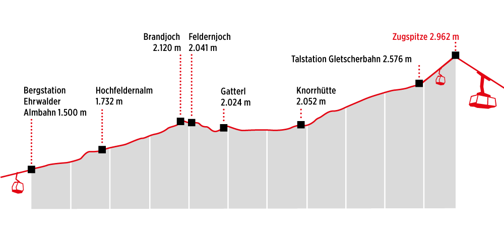
From the valley station of the Ehrwalder Alm cable car you proceed on the path up through the meadows to the Ehrwalder Alm. Continue past the Pest Kapelle and via the Max Klotz Steig, past the Hochfeldernalm und up to the Joch 'Am Brand' (2,120m). Stay on the path to the Fledernjöchl which dips slightly to 2.041m. Continue until you reach the point where the path divides for the Steinernes Hüttl and take the left hand fork which heads in a north easterly direction on towards the Gatterl. The Plattsteig takes you over rough scree and snow fields to the Knorr Hut. Continue to climb gently up to and across the Zugspitzplatt to the Schneefernerhaus and from there follow the marked path which is secured by cable in a north easterly direction to the peak. You could also take the Gletscherbahn up to the peak from the Zugspitzplatt if you prefer. We suggest to buy the Hiking-Ticket "Gatterl".
Bergrestaurants- en hutten
| Bergrestaurants- en hutten | Hoogte | Wandeltijd | Moeilijkheidsgraad |
| Tirolerhaus | 1.500 m | ||
| Ehrwalder Alm - the Eatery | 1.500 m | ||
| Alpenglühn | 1.500 m | 5 min. | makkelijk |
| Ganghoferhütte | 1.282 m | 20 min. | makkelijk |
| Hochfelderalm | 1.732 m | 45 min. | makkelijk |
| Seebenalm | 1.575 m | 1 – 1,5 uur | makkelijk |
| Tillfussalm | 1.382 m | 1,5 – 2 uur | makkelijk |
| Coburger Hütte | 1.917 m | 2 – 2,5 uur | middelzwaar |
| Gaistalalm | 1.366 m | 2 – 2,5 uur | makkelijk |
| Hämmermoosalm | 1.417 m | 3 – 3,5 uur | makkelijk |
| Steinernes Hüttl | 1.930 m | 3,5 uur | middelzwaar |
| Knorrhütte | 2.052 m | 3,5 uur | middelzwaar |
| Rotmoosalm | 1.904 m | 3,5 – 4 uur | middelzwaar |
| Gipfelrestaurant Zugspitze | 2.962 m | 5,5 – 6 uur | zwaar |
| Münchner Haus | 2.962 m | 5,5 – 6 h uur | zwaar |
Gasten die willen deelnemen aan een begeleide wandeling, kunnen contact opnemen met de plaatselijke bergsportscholen en berggidsen in Ehrwald, Lermoos & Biberwier